A view from the top of Ben Chracaig looking South towards the Cuillins
We begin with the map of the lands of Ben Chracaig (Figure 1). The walk starts at the footbridge, which you can reach either from the parking lot by the shore, or by a path down from the front of the Cuillin Hills Hotel. Enter through the gate after crossing the bridge. There are three walks you can take: a short walk out to the point (Sgeir Mhor) and back; a longer walk, which continues on the new section of footpath along the shore to the wall at the edge of the property and back; and finally, a more strenuous walk, which climbs steeply up alongside the wall and around the perimeter of the land, ending back at the Cuillin Hills Hotel.
Another strenuous but rewarding hike is to climb a narrow path, which begins behind the Cairn and reaches the top of the sea cliffs. Walking along the top of the cliffs you eventually meet the circular walk at the wall, from where you may either turn left to return around the back of the property, or turn right and make a steep descent to the end of the wall near the shore and return along the shore path.

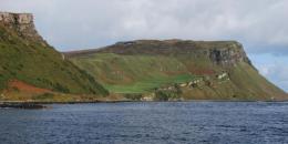
The walk east towards Sgeir Mhor ("The Black Rock") which boats must take care to avoid as they enter Portree Loch, with Ben Tianavaig in the background.